Uploading...
Overall progress...
0%
File progress...
0%
Edit event: Lenggries - Benediktenwand - Lenggries
T3 - Lenggries - Benediktenwand - Lenggries
 Organized by:
Route
Lenggries to Benediktenwand
| Elevation gain |
| Elevation loss |
| Distance |
| Duration |
| Highest altitude |
| Rating |
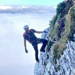
Gallery
Participants
You need to be logged in to see the participants
Weather
°
°
°
°
Description
The BRB to Lenggries doesn't seem to be affected by the strike this week so I plan to hike to Benediktenwand from the town and head back to where we start. The plan is to take the BRB RB56 departing from Hauptbahnhof at 0704 so let's meet there at 0645. I expect we will be back in Lenggries before 17 and we should therefore be back in Munich by around 1930. I don't think there will be any opening huts along the way so please bring food and drinks for the whole trip.
Good to know
You may want to bring the following (non-exhaustive list):
- Food and water
- Hiking sticks
- Power bank
- Phone with the maps loaded
- Spikes and gaiters
- Headlamp
- 49€ ticket
Disclaimer: Hiking can be dangerous. I am not a mountain guide. Everybody is responsible for her/himself. Make yourself familiar with the route and its requirements. It's recommended to download a map and bring a cell phone and first aid kit for emergencies.
Comments
Chid
2 years ago
Hello Travis. I live in Ingolstadt and the earliest train to Munich comes only at 06:46. So, I won't be able to meet you exactly at 06:45. But, I will meet you at ~07:00. Hope this is okay 🙂
1
|
0
Chid
2 years ago
Okay no problem 🙂 see you in some other hike then
1
|
0

Travis Tang
2 years ago
Hi man, not sure why you changed the decision I actually gave you a thumbs up after someone gave you a thumbs down for whatever reason. It's totally fine for me as long as you hop on the train at 0704, which I think you should have plenty of time to since you're there at 0646 and it won't take 15 minutes to go from platform 20 to platform 33. Anyways if you change your mind and decided to join again feel free to do so, otherwise see you in other hikes!
1
|
0
Chid
2 years ago
Ohhh 😅 I thought you did the thumbs down. I couldn't see who it was. Perfect then 👍🙂 I will join you on this hike. See you tomorrow.
1
|
0
Chid
2 years ago
Suggested change:
The map only goes until Enzianhütte hence, the 18.4 km total distance. If we have to return to Lenggries, the total distance will be app. 26km.
0
|
0
Travis Tang
2 years ago
Updated the route, thanks
0
|
0
Chid
2 years ago
Hey seems like it's only going to be just the two of us. It'll be rather boring. I think I'll the hike 😅 sorry.
I can't unjoin the hike now, so just informing you that I won't be coming. See you in some other hike.
0
|
0
Travis Tang
2 years ago
A comment of what happened during the hike: I started off by loading the wrong route (Benediktenbeuern to Lenggries) on my map and went up to Brauneck. Afterwards I tried to proceed by going along the ridge but there are deep and fresh snow, having no footprints and poor visibility (see one of the photos I uploaded) I decided to not risk it and return to the ski track and proceed from the south of the ridge instead. After reaching Probstalmsattel the snow is getting deeper and my speed is slowed to crawling. Although It was less than 1,5km from the peak, i decided to turn around because I need walk additional 12km to Lenggries before it gets dark. The total length I covered is therefore 24.7km and 1350hm climb
0
|
0