Uploading...
Overall progress...
0%
File progress...
0%
Edit event: [Switzerland] 68.Thursday's night after-work Uetliberg (from Albisgütli)
T2 - [Switzerland] 68.Thursday's night after-work Uetliberg (from Albisgütli)
 Organized by:
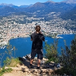
Route
Uetliberg (from Albisgütli)
| Elevation gain |
| Elevation loss |
| Distance |
| Duration |
| Highest altitude |
| Rating |
Gallery
Participants
You need to be logged in to see the participants
Weather
°
°
°
°
Description
General information
Meeting point: Near the bench at the start of the trail. Maps link: https://goo.gl/maps/LgCULujv3g9gct269

Easily accessible by public transport.
By bike, you need a little uphill endurance which could be a good warmup activity.
There is also payable parking.
Starting time: 18h30. That is the starting time, we don't wait for latecomers
Pace: beginner-friendly
Route: T2. We
will use the route trough the woods to ascent and panoramic route to descent. Both routes are relatively simple with easy orientation. We will need approximately 50 minutes to go up.
Weather: Regular weather is expected this Thursday. The temperatures are low so have worm clothes. The event is held in any weather, bring a rain jacket or an umbrella in case of rainy weather. It is a night hike.
Gear
Recommended: hiking, approach, trail running shoes, worm clothes, water, lamp
Comments
Severin Scherrer
2 years ago
Might get tight for me, but I can also catch up. I assume you head counter clockwise.
0
|
0