Uploading...
Overall progress...
0%
File progress...
0%
Edit event: Rapperswil - Flumserberg 50km!
T2 - Rapperswil - Flumserberg 50km!
 Organized by:
Route
Rapperswil - Flumserberg 50km!
| Elevation gain |
| Elevation loss |
| Distance |
| Duration |
| Highest altitude |
| Rating |
Gallery
Participants
You need to be logged in to see the participants
Weather
°
°
°
°
Description
Details
How about doing something "a bit" longer, once in a while? A bit more challenging?
Then - here it is.
Plan is to hike from Rapperswil SG to Flumserberg Tannenboden. Yes, I am serious (or… am I…?). It's mostly flat, going along the lakes. Just at the end, there's quite some ascent.
As the hike is VERY long, I do NOT (❗️) plan to make a lot of stops. The pace will also be higher than on my usual hikes. Which is why the number of participants is limited.
We have to catch the last bus from Tannenboden, which leaves "early" - at 21:30 (9.30pm). According to different apps, it is "easily" doable to catch it.
A note about the date: I posted this on 2024-04-02, 11 days before. If the weather on the 13th isn't good, I'll postpone.
Usually, I'd go to a restaurant. Let's see how destroyed we all are, once we arrive at the destination.
· 🚶 Start point (for the hike): Rapperswil SG
· 🏁 Destination: Flumserberg Tannenboden
· ⏳ Duration: about 12 hours of hike (⚠⚠)
· ↔️ Distance: 50 km (⚠⚠️)
· ⬆️ Ascent: 1'539 hm (‼️)
· ⬇️ Descent: 639 hm
· ⏬ Lowest point: 406 m
· ⏫ Highest point: 1'343 m
(Note: data taken from swisstopo and LocusMap. Different apps calculate these data differently.)
Equipment
PACK LIGHTLY! It's LONG!
· Hiking poles: Suggested
· Proper boots – VERY long distance!
· Layers of clothes
· Sun protection
· Water: something to drink. There are fountains and super markets along the way.
· Picnic: There’ll be a some stops for eating a bit. Get protein bars!
· Money: Nothing special.
Links:
· Telegram Group Chat (🥾 Hiking in Switzerland ⛰️)
Route (GPX):
· bikerouter (the source - planned there…)
· LocusMap (click on Export — THIS is the route we're going to go)
· SchweizMobil (the same…)
Public transportation
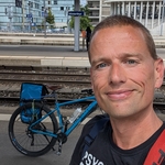
Meeting point: Meet in Rapperswil SG at the train station.
Time: 06:46 — that's when I will arrive.
Comments

Prathamesh
1 year ago
Hi Alexander, are you planning to increase participant count?
0
|
0
Alexander S
1 year ago
Hi. No, I do not. It's also on Meetup. With both sites, we're already a group of 10. For such a distance, I think that this is already quite big. I do not want to make it bigger.
1
|
0
Prathamesh
1 year ago
Make sense. Thanks. See you on Rigimarsch.
0
|
0
Alexander S
1 year ago
(I will post the exact same text in the group, meetup, and hiking-buddies.)
Our private "megamarsch" is coming up soon. I'd like to share a few thoughts and would pretty much encourage feedback, as I'm of course also unsure…
At best in the Telegram group @ https://t.me/+PtoFO7DW-Dc1NmNk or e-mail a@skwar.me or here.
I aim to do between 4 and 5 km/h (IOW: 12 to 15 min/km). This might be doable - on the flats.
Distance in flatland is about 42km, so walking time will be about 8 to 11 hours.
The last 6km up to Tannenboden are steep and thus slower — it's an ascent of 800m in 6km.
I guess that this will take about 2 to 3 hours, as it's after quite some distance.
0
|
0
Alexander S
1 year ago
So, we'll be walking for a maximum of 14 hours.
Start is at about 07:00 in the morning. Last bus in Tannenboden leaves at 21:30.
If we manage to do about 5 km/h, we'll also have enough time for some breaks.
As for what to eat — I'll go by this: https://www.megamarsch.de/post/die-optimale-ern%C3%A4hrung-f%C3%BCr-deinen-megamarsch
So on Friday, a small portion of pasta (like 600g 😉). And during the hike: Trockenfrüchte, frisches Obst, warmen Brühen oder Nussriegel.
0
|
0
Alexander S
1 year ago
No sandwiches or such. I also do **NOT** plan to have long breaks for that. But, let's see…
And lastly: What to bring along?
=> https://naturefreex.com/ausruestung-packliste-100-km-marsch/
Leave heavy stuff like cameras and such at home!
0
|
0
Alexander Berger
1 year ago
Hi Alexander, I would be careful using the list what to bring to eat, as the recommendation for megamarsch is done with the assumption that they provide points with food and drinks on the way. and on these points they offer sandwiches and warm soup. I would not go for 50km hike with only Nussriegel and Trockenfrühte. And also a pair of extra socks and one extra t-shirts for change could be useful. Just share my ideas from 100km Marsch experience:).
0
|
0