Uploading...
Overall progress...
0%
File progress...
0%
Edit event: [CH] Monte Cordonico, Cardada and Madonna del Sasso loop from Locarno
T2 - [CH] Monte Cordonico, Cardada and Madonna del Sasso loop from Locarno
20Apr
Sat
10:15
Bus stop at the Locarno station (you can find a link to the exact location in the description)
 Organized by:
Atanas Bayraktarov
Organized by:
Atanas Bayraktarov
Route
Monte Cordonico, Cardada and Madonna del Sasso - loop tour
| Elevation gain |
| Elevation loss |
| Distance |
| Duration |
| Highest altitude |
| Rating |
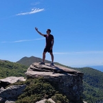
Gallery
Participants
You need to be logged in to see the participants
Weather
°
°
°
°
Description
Ladies and Gentleman,
Let's visit the bright side of the Alps !
The route will pass through these highlights:
Locarno, Cardada and Madonna del Sasso ,
Those who want to come by public transport should create a virtual car (or join mine) in the carpool.
Starting and end point: Locarno train station. exact location: https://maps.app.goo.gl/5zJ2rnsAH2VRJxnH7
How to arrive there (from Zurich HB):
08:05 Zurich HB (IR 46) -> 08:49 Arth-Goldau (IC 21) ->09:49 Bellinzona (S20) -> 10:15 Locarno
Elevation gain and loss: around 1,180 m
Highest point: 1346m
Pace: Moderate, a good level of fitness is required
Everyone should have: Hiking shoes, proper clothes (depending on the weather), food, water, sunscreen.
I might cancel or reschedule the event in case the weather deteriorates by Saturday (this will probably not happen)
Important: Download the .gpx file and load it into a proper app (Swisstopo for example). If the file fails to load into the app, try renaming it and setting the extension to .gpx.
Link to the Whatsapp group: https://chat.whatsapp.com/F43pu4G0yYc95v4RK6598W
Optional: Swimsuit, the water temperature of the lake is around 12-13 degrees Celsius
Everyone joins at their own risk.
Best regards
Comments
Atanas Bayraktarov
1 year ago
Link to the Whatsapp group: https://chat.whatsapp.com/F43pu4G0yYc95v4RK6598W
0
|
0