Uploading...
Overall progress...
0%
File progress...
0%
Edit event: Katzenkopf (1817 m), Königsstand (1453 m) from Garmisch Bhf
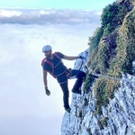
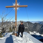
T4 - Katzenkopf (1817 m), Königsstand (1453 m) from Garmisch Bhf
 Organized by:
Route
Katzenkopf (1817 m), Königsstand (1453 m) from Garmisch Bhf
| Elevation gain |
| Elevation loss |
| Distance |
| Duration |
| Highest altitude |
| Rating |
Gallery
Participants
You need to be logged in to see the participants
Weather
°
°
°
°
Description
Meeting Time: 7:05 at München Hbf Gleis(Plattform) 28. Train leaves at 7:13. -->RB61 to Garmisch
Important: It is neccesary to have Deutschland tickt(49 euro) otherwise you should by yourself.
Imporant to know:
this hiking is a challenging mountain hike that requires surefootedness and freedom from vertigo. The trail is exposed in some places. Over the nearly 10 km route, approximately 1060 meters of altitude difference must be overcome.
Route maybe modified based on the conditions of the day of the hike.
Wish to board the train to Munich before it goes dark.
Go through the route and if possible save the gpx and the map of the area in your navigation device for offline use.
Mandatory: Come with a good mood and smile :)
For queries, write in comments
Note: Please unjoin the event well in advance, if you don't plan to come. You cannot unjoin the event when it is starting in less than 12 hours
Important Info:
Because of Weather condition Event can change.
Pace:
To Peak-->3 Km/h
Come back --> 4 Km/h
Estimated Plan:
1- Munich Bhf-->Garmisch Bahnhof(Train RE61):
07:13 -->08:23
3- Hiking : apptrox. 7 H + 1 H Rest-->
8:23-->16:23
St. Martinshütte -->in comback
app. 15:00-16:00
4- Garmisch Bahnhof(Train RE61) -->München Bhf
17:05 --> 18:26
Good to know
Remember to bring with you:
--Food/water
--Hiking poles
-- Rain protection
--Headlamp and first aid kit (for emergencies)
--Cash for optionally the beer garden / restaurant
--Please bring your food/drink for yourself in advance.
--DAV Insurrance
Disclaimer: Hiking can be dangerous. I am not a mountain guide. Everybody is responsible for themselves. Please make yourself familiar with the route and its requirements. Additionally, you could download the map, bring a cell phone and a first aid kit.
Comments

Sodayf Ahadi
1 year ago
Hello everybody
Unfortunately the weather is not suitable at this weekend for this hiking. There is Rain + storm
0
|
0
Sodayf Ahadi
1 year ago
WhatsApp group: https://chat.whatsapp.com/F8PP1CDSturCYVwAyfgDMO
0
|
0

Muralidharan Jagannathan
1 year ago
how is the weather like? I got some thunderstorms warnings
0
|
0
Chid
1 year ago
It is predicted to rain in the evening from 15:00 or 16:00. So, we should be fine. Just carry a rain jacket to be on the safer side :-)
0
|
0
Sagar BV
1 year ago
Hello, Apologies for the delayed decision. I would like to drop off form tomorrow’s hike.
0
|
0