Uploading...
Overall progress...
0%
File progress...
0%
Edit event: Lachenspitze (2130 m) Knappenkopf (2066 m) Kugelhorn (2126 m) Rauhhorn (2240 m) Gaiseck (2212 m
T5 - Lachenspitze (2130 m) Knappenkopf (2066 m) Kugelhorn (2126 m) Rauhhorn (2240 m) Gaiseck (2212 m
 Organized by:
Route
Lachenspitze (2130 m) Knappenkopf (2066 m) Kugelhorn (2126 m) Rauhhorn (2240 m) Gaiseck (2212 m
| Elevation gain |
| Elevation loss |
| Distance |
| Duration |
| Highest altitude |
| Rating |
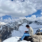
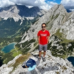
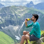
Gallery
Participants
You need to be logged in to see the participants
Weather
°
°
°
°
Description
Not beginner friendly, Alpine Hiking experience (Via ferreta experienceneeded)
Join me for an extraordinary alpine hike featuring stunning lakes, peaks, and a beautiful ridge. We'll tackle a via ferrata after Lachenspitze Hütte; it's a short one, followed by more scenic hiking.
Plans may change due to weather or car-sharing logistics. If you have a different start time in mind, let's discuss it if you are willing to pool your car.
I welcome experienced hikers who can keep up with the group(this would rather fast pace in non technical parts). Please bring necessary equipment, including a via ferrata set, helmet, and your ID for border crossing.
Note that I am not a mountain guide, so you are responsible for your own safety. A WhatsApp group will be set up for updates and coordination.
Looking forward to an amazing hike!
Best regards,
Good to know
**Mountain Trail Classification**
**Valley Trails (not classified, T1):** Near-valley, wide, easy-to-walk paths without any risk of falling. Usually not maintained and marked by the Alpine Club.
**Simple Mountain Trails (blue, T2):** Mostly narrow, can be steep, and have no dangerous sections.
**Moderately Difficult Mountain Trails (red, T3):** Mostly narrow, often steep, and may have dangerous sections. Short secured sections (e.g., with a wire rope) may occur.
**Difficult Mountain Trails (black, T4 – T6):** Narrow, often steep, and dangerous. Frequently secured sections and/or simple climbing sections requiring the use of hands. Surefootedness and a head for heights are absolutely necessary.
**SAC Hiking Scale**
The Swiss Alpine Club's hiking scale was introduced in 2002 and is divided into six different grades:
**T1 (Easy Valley Trail, yellow):** Well-marked path. If present, exposed sections are very well secured. The risk of falling can be largely excluded with normal behavior. Suitable even with sneakers. Navigation is straightforward, usually possible without a map.
**T2 (Simple Mountain Trail, DAV: blue, SAC: white-red-white):** Trail with a continuous path. The terrain is partially steep, and the risk of falling cannot be completely excluded. Some surefootedness is needed; trekking shoes are recommended. Basic navigation skills required.
**T3 (Moderately Difficult Mountain Trail, DAV: red, SAC: white-red-white/white-blue-white):** Trail not necessarily continuously visible on the ground. Exposed sections may be secured with ropes or chains. Hands may be needed for balance. Partially exposed sections with a risk of falling, scree fields, and pathless rocky terrain. Good surefootedness, good trekking shoes needed. Average navigation skills. Basic alpine experience.
**T4 (Difficult Mountain Trail, DAV: black, SAC: white-blue-white):** Trail may not always be visible. Hands are needed at certain points for progression. The terrain is quite exposed, with tricky grassy slopes, rocky terrain. In high mountains, possibly simple snowfields and bare glacier crossings. Familiarity with exposed terrain is needed. Sturdy trekking shoes. Some terrain assessment and good navigation skills. Alpine experience. Retreat can be difficult in case of bad weather.
**T5 (Difficult Mountain Trail, DAV: black, SAC: white-blue-white):** Often pathless. Some simple climbing sections. Exposed, challenging terrain with steep rocky terrain. In high mountains, possibly bare glaciers and snowfields with a risk of slipping. Mountaineering boots. Confident terrain assessment and very good navigation skills. Good alpine experience in high alpine terrain. Basic knowledge of using ice axes and ropes.
**T6 (Difficult Mountain Trail, DAV: black, SAC: white-blue-white):** Mostly pathless. Climbing sections up to grade II. Frequently very exposed. Tricky rocky terrain. Bare glaciers with an increased risk of slipping. Mostly unmarked. Excellent navigation skills. Extensive alpine experience and familiarity with technical alpine equipment.
**Mountain trails of grades T5 and T6 are sometimes considered "alpine routes" and can be as challenging as easier high mountain tours (L, WS) but typically without fixed protection.**
**Table of Trail Categories: Germany, Austria, and Switzerland Comparison**
Trail categories: Germany, Austria, and Switzerland in comparison. Source: DAV
**Via Ferrata Scale**
**A (easy):** Terrain flat to steep, mostly rocky or interspersed with rocks, exposed sections possible. Secured with wire ropes, chains, iron rungs, and occasionally short ladders; movement is mostly possible without using the securing installations. Via ferrata equipment recommended.
**B (moderately difficult):** Steeper rocky terrain, sometimes small steps, exposed sections are to be expected. Secured with wire ropes, chains, iron rungs, step pins, longer ladders (sometimes vertical); without using the securing installations, difficulties up to grade III are to be expected (difficulties higher in ladder sections). Via ferrata equipment recommended.
**C (difficult):** Steep to very steep rocky terrain, mostly small steps, longer or very frequent exposed sections. Secured with wire ropes, iron rungs, step pins, often longer and even overhanging ladders. Rungs and pins can be further apart; in vertical sections sometimes only a wire rope. Requires strength and movement technique similar to climbing grade III. Longer routes in this difficulty are major via ferrata enterprises. Via ferrata equipment highly recommended, with rope protection for the untrained or children.
Higher via ferrata difficulties do not usually occur on mountain trails.
**UIAA Scale for Climbing Difficulties**
**I:** Low difficulty, simplest form of rock climbing (not easy walking terrain). Hands are needed for balance. Inexperienced climbers must be roped up. A head for heights is necessary.
**II:** Moderate difficulty. Here, climbing begins, requiring the three-point technique (always having three solid points of contact from two hands and two feet).
**III:** Medium difficulty. Vertical sections or well-gripped overhangs require effort. Only experienced climbers should attempt this without a rope.
Comments
Mayank Kava
1 year ago
Hi, could you please elaborate more on this Hike. what's the destination peak? what time do we start and do we drive by car or train?
0
|
0

Amir ak
1 year ago
Hi, all is in description, we will have multi peaks not one peak. We are waiting for carpool from Munich otherwise is really difficult to get there . Carpool and the time is also written there
0
|
0
Vinay Patel
1 year ago
Hello Amir ak, is it possible to reschedule this hike for Saturday ( June 29)? Weather looks better on Saturday and I would like to add my car for carpooling.
0
|
0
Amir ak
1 year ago
Hi Vinny, if you are willing to pool a car then I will shift it, please note that it is better to start as early as possible.
0
|
0
Vinay Patel
1 year ago
Hi Amir, thanks for rescheduling the hike on Saturday. I have added the car and set the meeting point at P+R Trudering Bf Munich in front of the Lohi office. Maybe we can create a Whatsapp group and coordinate the meeting point that is convenient for everyone.
1
|
0
Amir ak
1 year ago
Please join the WhatsApp group for better coordination with regards to car pool https://chat.whatsapp.com/EiZ1tC44ZmoFN5xmLid9DV
0
|
0
Prayag Miskin
1 year ago
Request to please post pictures of Schrecksee conditions after the hike!
0
|
0