Uploading...
Overall progress...
0%
File progress...
0%
Edit event: Wörner and Mittenwalder Höhenweg (UIAA climbing up to I+/II & A/B)
T5 - Wörner and Mittenwalder Höhenweg (UIAA climbing up to I+/II & A/B)
 Organized by:
Route
Wörner and Mittenwalder Höhenweg
| Elevation gain |
| Elevation loss |
| Distance |
| Duration |
| Highest altitude |
| Rating |
Gallery
Participants
You need to be logged in to see the participants
Weather
°
°
°
°
Description
Not beginner friendly, Alpine Hiking experience ((UIAA climbing up to I+/II & A/B))
Plans may change due to weather-
I welcome experienced hikers who can keep up with the group(this would rather fast pace in non technical parts >540 hm/h). Please bring necessary equipment, including a via ferrata set, helmet, and your ID for border crossing
Note that I am not a mountain guide, so you are responsible for your own safety. A WhatsApp group will be set up for updates and coordination 12 hours before hike.
Helmed is required & via ferrata set is recommended for hohenweg.
Disclaimer: You are responsible for yourself. Hiking can be dangerous, I am not a mountain guide and this is not a guided tour. Make yourself familiar with the route and its requirements. It is recommended to have DAV Membership/Insurance.
About:
Mittenwalder The Wörner is an alpine highlight on the Bavarian side of the Karwendel. The Bavarian Karwendel has relatively modest dimensions compared to the overall area of this mountain range. Of the four major rock formations, only the Northern Chain touches the Bavarian responsibilities. The state border with Austria runs directly along the vertical axis of this mountain range. The town of Mittenwald in Upper Bavaria is the central starting point for excursions into the northern Karwendel bastion. Compared to the Austrian side, the area accessible from there has been somewhat civilized through the construction of paths. The hotspot is certainly the Karwendelbahn cable car, specifically the rocky surroundings of its mountain station, as well as the heavily trafficked Mittenwald Ridgeway that starts from there.
In contrast, the classic Karwendel range is known for its primitive nature and restrained development. Those who want to experience this from Mittenwald and are blessed with the necessary skills set their sights on the mighty Wörner. The mountain is a true Karwendel peak with everything that entails: a long approach, significant elevation gain, and requiring the use of hands to climb. Despite its difficulty, the Wörner is frequently climbed. For those who don't want to tackle the entire challenge in one go, it can be done in two parts with an overnight stay at the Hochlandhütte. While this doesn't make the technical difficulties (climbing up to grade II) any easier, it means you won't be struggling with your stamina reserves when the going gets tough.
The mountain tour via the normal route on the Wörner falls into the category of easy climbing tours.
T4+ II
Advance from Wörnersattel over the narrow grassy ridge to the rock base of the Wörner. The start of the normal route is unmistakable. A sign, with a thought-provoking note regarding the expected difficulties, marks the beginning.
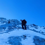
Expansive views into the summit flank
Expansive views into the summit flank
The first barrier is overcome with easy scrambling (I). Red markings show the ideal line to the summit from this point onward. The terrain eases a bit above this first hurdle. Move upwards in the extreme walking terrain immediately to the right of the northwest ridge. In the typically shattered rock of the Karwendel, this is no trivial matter. At approximately 2,300 meters, the route veers to the right of the ridge crest.
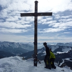
The final meters to the summit
The final meters to the summit
Traverse into the west flank with some ups and downs. This stage has a decent trail, but due to the crumbly ground, it must be navigated carefully. An unmistakable red arrow painted on the rock ends the traverse. Here, the actual climbing begins – the arrow directs the summit aspirant to make contact with the rock. About 180 vertical meters remain to the geological zenith.
The first meters immediately represent the crux of the tour. A steep rock step with small holds requires concentrated climbing (II). The subsequent section is quite airy, as the terrain drops steeply to the Wörnerboden below. Ascend skyward through the rock in a sweeping leftward arc (continuous I). Finally, the terrain eases a bit and the summit push ends via walking terrain at the Wörner cross (2,476 m).
Tour description: Descent
Carefully scramble down the west flank to Wörnersattel, return to the mountaineers' accommodation, and finish our alpine tour with the hike back to Mittenwald. For many (including myself), returning via the ascent route is the preferred way.
For those who enjoy varied round tours, the district offers alternatives for the return route. For example, a descent from Wörnersattel to the northeast and a return via Seinsgraben is conceivable. The section between Hochlandhütte and Dammkar also offers some variants. With a good topographic map, you can plan something individually. However, you should not lose sight of the length of the trails.
What appears as a short detour on a map often turns into a relentless endurance test on site (this applies, for example, to the mentioned return via Seinsgraben).
Mittenwald Höhenweg
we will take following connection :

Good to know
.
**Disclaimer**
Please read the following carefully before participating in the hike:
1. **Self-Guided Activity**: This event is not a guided tour. The organizer is merely facilitating the coordination of participants. Each individual is responsible for their own actions, choices, and judgments.
2. **Self-Navigation**: Every participant is responsible for navigating themselves on the suggested route. You must have the necessary skills, experience, and equipment to independently complete the hike.
3. **Personal Responsibility**: You are fully responsible for your own safety and well-being during the hike. This includes assessing your fitness for the activity, ensuring you have adequate equipment, preparing for all weather conditions, and having sufficient supplies. If professional rescue services are required, you will be responsible for the costs.
4. **Insurance**: By participating, you confirm that you have sufficient insurance coverage, such as membership with the German Alpine Club (DAV), Mountain Rescue Service (Bergrettung), or a similar organization, to cover any potential accidents or emergencies that may occur during the hike.
5. **Acknowledgment of Risk**: By joining this hike, you acknowledge and accept that hiking involves inherent risks, which can lead to injuries or death. You participate at your own risk.
6. **Liability Release**: The organizer holds no responsibility for any injuries, accidents, or deaths that might result directly or indirectly from this event. The organizer does not warrant the accuracy of the event description.
7. **Group Dynamics**: If you decide to leave the group (e.g., going ahead or stopping without reason) or do not bring the required gear, you are officially considered to have left the group, and the group will not search for you.
By joining this event, you accept and agree to the terms outlined above. Please be aware that you participate at your own risk and responsibility.
**Mountain Trail Classification**
**Valley Trails (not classified, T1):** Near-valley, wide, easy-to-walk paths without any risk of falling. Usually not maintained and marked by the Alpine Club.
**Simple Mountain Trails (blue, T2):** Mostly narrow, can be steep, and have no dangerous sections.
**Moderately Difficult Mountain Trails (red, T3):** Mostly narrow, often steep, and may have dangerous sections. Short secured sections (e.g., with a wire rope) may occur.
**Difficult Mountain Trails (black, T4 – T6):** Narrow, often steep, and dangerous. Frequently secured sections and/or simple climbing sections requiring the use of hands. Surefootedness and a head for heights are absolutely necessary.
**SAC Hiking Scale**
The Swiss Alpine Club's hiking scale was introduced in 2002 and is divided into six different grades:
**T1 (Easy Valley Trail, yellow):** Well-marked path. If present, exposed sections are very well secured. The risk of falling can be largely excluded with normal behavior. Suitable even with sneakers. Navigation is straightforward, usually possible without a map.
**T2 (Simple Mountain Trail, DAV: blue, SAC: white-red-white):** Trail with a continuous path. The terrain is partially steep, and the risk of falling cannot be completely excluded. Some surefootedness is needed; trekking shoes are recommended. Basic navigation skills required.
**T3 (Moderately Difficult Mountain Trail, DAV: red, SAC: white-red-white/white-blue-white):** Trail not necessarily continuously visible on the ground. Exposed sections may be secured with ropes or chains. Hands may be needed for balance. Partially exposed sections with a risk of falling, scree fields, and pathless rocky terrain. Good surefootedness, good trekking shoes needed. Average navigation skills. Basic alpine experience.
**T4 (Difficult Mountain Trail, DAV: black, SAC: white-blue-white):** Trail may not always be visible. Hands are needed at certain points for progression. The terrain is quite exposed, with tricky grassy slopes, rocky terrain. In high mountains, possibly simple snowfields and bare glacier crossings. Familiarity with exposed terrain is needed. Sturdy trekking shoes. Some terrain assessment and good navigation skills. Alpine experience. Retreat can be difficult in case of bad weather.
**T5 (Difficult Mountain Trail, DAV: black, SAC: white-blue-white):** Often pathless. Some simple climbing sections. Exposed, challenging terrain with steep rocky terrain. In high mountains, possibly bare glaciers and snowfields with a risk of slipping. Mountaineering boots. Confident terrain assessment and very good navigation skills. Good alpine experience in high alpine terrain. Basic knowledge of using ice axes and ropes.
**T6 (Difficult Mountain Trail, DAV: black, SAC: white-blue-white):** Mostly pathless. Climbing sections up to grade II. Frequently very exposed. Tricky rocky terrain. Bare glaciers with an increased risk of slipping. Mostly unmarked. Excellent navigation skills. Extensive alpine experience and familiarity with technical alpine equipment.
**Mountain trails of grades T5 and T6 are sometimes considered "alpine routes" and can be as challenging as easier high mountain tours (L, WS) but typically without fixed protection.**
**Table of Trail Categories: Germany, Austria, and Switzerland Comparison**
Trail categories: Germany, Austria, and Switzerland in comparison. Source: DAV
**Via Ferrata Scale**
**A (easy):** Terrain flat to steep, mostly rocky or interspersed with rocks, exposed sections possible. Secured with wire ropes, chains, iron rungs, and occasionally short ladders; movement is mostly possible without using the securing installations. Via ferrata equipment recommended.
**B (moderately difficult):** Steeper rocky terrain, sometimes small steps, exposed sections are to be expected. Secured with wire ropes, chains, iron rungs, step pins, longer ladders (sometimes vertical); without using the securing installations, difficulties up to grade III are to be expected (difficulties higher in ladder sections). Via ferrata equipment recommended.
**C (difficult):** Steep to very steep rocky terrain, mostly small steps, longer or very frequent exposed sections. Secured with wire ropes, iron rungs, step pins, often longer and even overhanging ladders. Rungs and pins can be further apart; in vertical sections sometimes only a wire rope. Requires strength and movement technique similar to climbing grade III. Longer routes in this difficulty are major via ferrata enterprises. Via ferrata equipment highly recommended, with rope protection for the untrained or children.
Higher via ferrata difficulties do not usually occur on mountain trails.
**UIAA Scale for Climbing Difficulties**
**I:** Low difficulty, simplest form of rock climbing (not easy walking terrain). Hands are needed for balance. Inexperienced climbers must be roped up. A head for heights is necessary.
**II:** Moderate difficulty. Here, climbing begins, requiring the three-point technique (always having three solid points of contact from two hands and two feet).
**III:** Medium difficulty. Vertical sections or well-gripped overhangs require effort. Only experienced climbers should attempt this without a rope.
Comments
Sim On
1 year ago
Dear Amir, thank you for organizing this amazing tour. It was not obvious to me from the description. do you plan to do it as a short round tour and go back to Mittenwald or will we end the hike at Scharnitz?
0
|
0

Amir ak
1 year ago
Apparently the weather tomorrow is not going to improve, that's why is not best day to solo this hike. Sorry I have to postpone it
1
|
0

Travis Tang
1 year ago
Ah brother you won’t be soloing this hike as I’ll also be joining 🤣But anyways I think it’s a good decision to postpone it as well. See you in 2 weeks!
0
|
0
Amir ak
1 year ago
That's good that you are still joining, let's hope that the weather in two weeks is on our favorite
0
|
0
Amir ak
1 year ago
Overnight into Saturday there is a chance of thunderstorms and local showers. As more clouds move in in the course of day the sky becomes overcast but it should stay dry. The sun will not be visible. There is only a low chance of Precipitation (around 30%). Temperature highs are likely to reach 18 °C. Night and day blows a light breeze (7 to 12 km/h). Winds blowing overnight from Northeast and by day from North. The weather forecast for Mittenwald for Saturday can be accurate in parts but deviations are ex
0
|
0
Amir ak
1 year ago
Looks okay for tomorrow
0
|
0
Sohaib Iftikhar
1 year ago
Hi guys, did you also do the hohenweg? is there still snow fields or is it entirely snow free.
0
|
0
Travis Tang
1 year ago
Hi Sohaib, We skipped it because it started to rain and the visibility was really poor. However I remember there are other groups on HB who did the Höhenweg the day after, maybe you can ask them:
https://www.hiking-buddies.com/routes/events/9808/
https://www.hiking-buddies.com/routes/events/9665/
0
|
0