Uploading...
Overall progress...
0%
File progress...
0%
Edit event: [CH] Via Alpina Stage 2: Sargans - Weisstannen
T2 - [CH] Via Alpina Stage 2: Sargans - Weisstannen
 Organized by:
Route
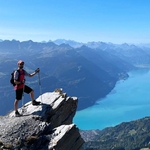
Via Alpina Stage 2: Sargans - Weisstannen
| Elevation gain |
| Elevation loss |
| Distance |
| Duration |
| Highest altitude |
| Rating |
Gallery
Participants
You need to be logged in to see the participants
Weather
°
°
°
°
Description
Hoi hikers,
Let's start/continue collecting stamps and kms on the Via Alpina. This time we start and finish in Canton St. Gallen, hiking along the Weisstannen valley.
More info: Via Alpina stage 2 and a nice description on Silvie's hiking blog.
The passbook can be ordered here: https://www.myswitzerland.com/en-ch/experiences/summer-autumn/hiking/via-alpina/via-alpina-hiking-passbook/#
I have a few to give away. Let me know until Friday 10 pm, if you need one.
Weather forecast: Finishing before the heavy rain arrives. Light rain may occur. Weisstannen
How to get there:
Journey by public transport: ZH HB - Sargans (Hooray, no change needed!)
The train (IC 3 to Chur) departs at 07:57 from ZH HB.
Journey by car: Use gps.
Meeting point:
9:05 AM - Sargans train station
There is a bus back to Sargans in every hour. XX:42. My plan to reach the bus at 12:42.
Hike:
- The hike will last ca. 3,5-4 hours with a lot of viewpoints.
- The pace will be medium/fast with enough time to admire the landscape, but
- NO lunch break during the hike, only at the end, while waiting for the bus.
Equipment:
- Proper hiking boots, poles, snacks, enough water, proper clothes acc. to the rainy weather, tick spray, good mood and fitness.
Standard Disclaimer:
This is not a guided tour, every individual is responsible for their actions, choices tand judgement. It is your own responsibility to assess your fitness condition for this hike, to assure adequate equipment (boots, clothes, etc.), insurance coverage and to check and evaluate the weather forecast. In case professional rescue services are required, you will be responsible for the costs.
The organiser holds no responsibility for any injuries or death that might result directly or indirectly from this event. The organiser does not warrant the accuracy of the description of the hike.
By joining the hike, you accept the terms explained above.
Please be aware that you join at your own risk.
Additional notes
- Out of respect for the others, please be on time. If you happen to be late, contact the organizer.
- Unjoining allowed until 12 hours before the start of the event. If you are unable to be join for whatever reason, contact the organizer.
Frequently asked questions
I don't see the "Join button" - how do I join?
Click on Carpool button, and then Join a car, or Add a car.
Comments
Botond Kovács-Nüszl
1 year ago
Whatsapp group: Whatsapp group: https://chat.whatsapp.com/BRDunQeno1HAOLs5Eat6t9
0
|
0