Uploading...
Overall progress...
0%
File progress...
0%
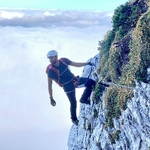
Edit event: Schliersee to Tegernsee over Baumgartenschneid
T4 - Schliersee to Tegernsee over Baumgartenschneid
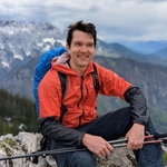
 Organized by:
Route
[Hike & Swim] Tegernsee to Schliersee over Baumgartenschneid*
| Elevation gain |
| Elevation loss |
| Distance |
| Duration |
| Highest altitude |
| Rating |
Gallery
Participants
You need to be logged in to see the participants
Weather
°
°
°
°
Description
Please join this WhatsApp group. We will share here all the pictures after the hike:
https://chat.whatsapp.com/CocwS4BE7oF0C2SKxxoPOC
———————————————————————————
Let's take a hiking trip from Schliersee to Tegernsee (longer version). This event is limited to a maximum of 12 people.
The duration, length and altitude you can find in the route description.
(The definitions about T1-T6 you can find unter this link: https://www.hiking-buddies.com/blog/2018/07/02/sac-hiking-scale/?fbclid=IwAR1vChqb_VYS-QP2RTKHapbNSS2xJPG9C8wxBsjcdBSrbI74fyyWKcbW4pQ).
We will go at the pace of ca. 400 hm/h and this should be not too exhausting to you.
Please only join if you think that the distance and altitude would be possible for you.
We will walk as 1 group. All together.
We will try to arrive in the evening at 7pm in Munich.
---------------------------------------
We will go swimming after/during the hike, if there is any lake or river available. Please bring your swimwear.
---------------------------------------
Details:
Platform and meeting time can be found in the event (train usually leaves 20 min after the proposed meeting time)
If you are late, then you need to find us on the train.
----------------------
Cost:
-train ticket: 0€ if you have Deutschland-Ticket.
Food:
Please bring enough food and 1-2l water with you.
If there will be no huts on the way, then probably after the hike, we can grab a drink/food at a restaurant in the village near the train station.
I would recommend to bring:
-hiking shoes
-hiking poles
--------------------------------------------
Disclaimer: Hiking can be dangerous. I am not a mountain guide. Everybody is responsible for her/himself. Make yourself familiar with the route and its requirements. It's recommended to download a map and bring a cell phone and first aid kit for emergencies.
If you decide to leave the group (go in front by yourself), then we won’t search for you.
Good to know
Attention:
We will follow the GPS route the whole time. If you decide not to follow the GPS route, then you have officially left the hike and will be removed from my hike.
Please let me know your phone number before the hike. If we get separated, we can call each other to figure out how to find each other again.
Comments
Chid
1 year ago
Hi Andy, thanks for organising this hike :-). But, I am a bit confused. I cannot see which part of this hike is T4.
0
|
0
Andreas Anselm
1 year ago
I think the yellow marked one in the map is meant as T4. Maybe it’s a mistake in the map. The map creates the T-Level by itself after uploading the gps.
1
|
0
Ester
1 year ago
I agree from path and slope looks more T2-T3 but perhaps it is not marked and hence T4? Not sure, we will see 😄
0
|
0
Ester
1 year ago
Hi ! Is the hike still confirmed?
0
|
0
Andreas Anselm
1 year ago
yes
0
|
0