Uploading...
Overall progress...
0%
File progress...
0%
Edit event: [CH] Nüenchamm - Talalpsee loop from Filzbach
T2 - [CH] Nüenchamm - Talalpsee loop from Filzbach
 Organized by:
Route
Nüenchamm - Talalpsee loop from Filzbach
| Elevation gain |
| Elevation loss |
| Distance |
| Duration |
| Highest altitude |
| Rating |
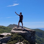
Gallery
Participants
You need to be logged in to see the participants
Weather
°
°
°
°
Description
Ladies and Gentleman,
I hereby present my plan for this weekend!
We will explore the mountains above the "Walensee" and hike up to the "Nüenchamm gipfel". We will make sure to enjoy the view from above, after that we will pass next to a mountain lake called "Talalpsee" (check the map for more details)
Those who want to come by public transport should create a virtual car (or join mine) in the carpool.
Starting and end point: Filzbach, Sportzentrum bus station,
https://maps.app.goo.gl/ehGj7kz7dPXiiMkSA
How to arrive there (from Zurich HB):
07:43 Zurich HB (S25) -> 08:28 Ziegelbrücke (S17) ->08:37 Mühlehorn(B 511) ->, 08:48 Filzbach, Sportzentrum
Elevation gain and loss: around 1200
Highest point: 1862m
Pace: Moderate
Everyone should have: Hiking shoes, proper clothes, food, water, sunscreen.
I might cancel or reschedule the event in case the weather deteriorates by Sunday
Important: Download the .gpx file and load it into a proper app (Swisstopo, Atlas...). If the file fails to load into the app, try renaming it and setting the extension to .gpx.
Optional: Once we've completed the official route, we can head down to the Walensee for a swim.
Link to the Whatsapp chat: https://chat.whatsapp.com/HQuhMyBmA8GCskde8yzQlC
Everyone joins at their own risk.
Best regards
Comments
Atanas Bayraktarov
1 year ago
Link to the Whatsapp chat: https://chat.whatsapp.com/HQuhMyBmA8GCskde8yzQlC
0
|
0
Atanas Bayraktarov
1 year ago
In case you can not click the Whatsapp chat in the comment, I added a proper link in the description.
Best Regards
0
|
0
Calin Cerchez
1 year ago
Hey, can I join you tomorrow?
0
|
0
Atanas Bayraktarov
1 year ago
yes, there is a free spot. join the hike. Best regards
0
|
0