Uploading...
Overall progress...
0%
File progress...
0%
Edit event: [CH] Barefoot Hike and Ridge from Gontenbad
T2 - [CH] Barefoot Hike and Ridge from Gontenbad
23Jun
Sun
10:00
Gontenbad station ( https://maps.app.goo.gl/taTUEngAFC592JwQ6 )
 Organized by:
Sascha Geisler
Organized by:
Sascha Geisler
Route
Barefoot Hike and Ridge Kronberg from Gontenbad
| Elevation gain |
| Elevation loss |
| Distance |
| Duration |
| Highest altitude |
| Rating |
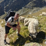
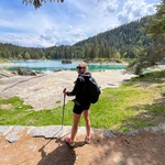
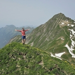
Gallery
Participants
You need to be logged in to see the participants
Weather
°
°
°
°
Description
whatsapp Link: https://chat.whatsapp.com/FTUGHYoODlU7B4MfLl5xQt
Dear hiking buddies.
for some time now i wanted to do the barefoothike in Appenzell, here is some info about it:
https://www.appenzell.ch/de/sommer/wandern/themenwanderwege/barfussweg.html
Of course there is the option to walk with shoes next to the designated path.
Since the orginal route is only 5.3 kilometers i created a hike around.
Barefoot hike is at the start, then we go up the mountain close to there and have a ridge hike for around 2 hours.
Some huts are also on the way.
End of the hike will again be in Gontenbad.
Time Frame:
10:00 meet and start
18:30 back at the station Gontenbad
Meeting point:
https://maps.app.goo.gl/ebpKCxW9h1RGwpE98
train station Gontenbad
Hike:
1000 height meters, 23Km, mostly on the ridge, not many trees
Picnic:
Picnic along the way
Equipment:
Bring enough water and sun protection.
There could be short periods of rain during the day.
Bring a small towel to clean your feet after the barefoot part.
Application:
As always there is the possibility to come by car.
Join the car pool and either create a car yourself or have a look who can take you there.
For those who come by public transport please create a "car" in the carpool with around 30 seats and use "public transport" as a description. That way others can join that one and we keep a good overview.
If that one is full, create another one with 30 seats please.
No maximum number of participants.
Standard Disclaimer:
I am not a mountain guide.
Please be aware that you join at your own risk.
For any questions, contact me here or on the Whatsapp group.
Comments
Sascha Geisler
1 year ago
Light rain announced, not the whole day but every now and then. Please bring rain clothes. There is still hope for some sun.
0
|
0
Ola Bąkowska
1 year ago
hi Sascha, i am sorry, I won’t be able to join the hike today. wish u all good fun :) and hopefully not so much rain
0
|
0
Anita Ch
1 year ago
Hi All, I will not join today the trip due to given weather conditions. Enjoy the trip!
0
|
0
Pawel Katarzynski
1 year ago
Hi, I need to skip this hike because of the weather
0
|
0
Joanna La
1 year ago
hi Sasha i will also skip the hike today because of the weather
0
|
0