Uploading...
Overall progress...
0%
File progress...
0%
Edit event: Hönig (2,034m)
T2 - Hönig (2,034m)
 Organized by:
Route
Hönig
| Elevation gain |
| Elevation loss |
| Distance |
| Duration |
| Highest altitude |
| Rating |
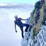
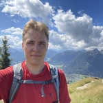
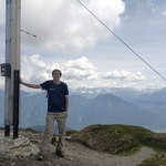
Gallery
Participants
You need to be logged in to see the participants
Weather
°
°
°
°
Description
NOTE: Since weather conditions are changing drastically over time and I planned this hike pretty early, I keep my rights to change the hiking date.
NOTE: Please check the gain and distance of the hike, it may not be beginner friendly.
We will meet at München Hbf (Gl. 31). Please be punctual!
The hike should take ca. 7-8 hours with an intermediate pace of 400 mph.
The plan is following:
8:13 - 9:24 (RB 61) München Hbf -> Garmisch
10:04 - 10:43 (RE 60) Garmisch -> Bichlbach Bergwang
11:00 - 19:00 hiking + lunch at Kögele Hütte
19:16 - 19:57 (S 7) Bichlbach Bergwang -> Garmisch
20:05 - 21:26 (RB 6) Garmisch -> München Hbf
It may change depending on the weather, hike & availability of the connections.
Sticks may be helpful to keep you safe.
Before the hike please join the WhatsApp group or send me a private message with your phone number.
WhatsApp group: https://chat.whatsapp.com/Cxim4OY7SWEDmSlJ8Nke4M
Good to know
Things to bring:
- Deutschland Ticket with ID card (UE) or passport (we are crossing Austrian boarder);
- hiking shoes;
- windproof and waterproof clothes;
- water (at least 3 l) and some food;
- sunscreen and sunglasses;
- DAV insurance;
- good energy and stamina.
Optional:
- hiking poles;
- first aid kit.
Note:
- Unjoining is allowed until 12 hours before the start of the event
- The organizer is no professional guide. Participants are responsible for themselves, must do their own research about the route, and must be able to navigate by themselves (in case the group splits for some reason, for example)
Disclaimer: Hiking can be dangerous. I am not a mountain guide. Everybody is responsible for themselves. Please make yourself familiar with the route and its requirements. Additionally, you could download the map, bring a cell phone and a first aid kit.
Comments
Chid
1 year ago
Hello Robert 👋 we climbed Roter Stein last Saturday and my route overlaps partially with the one you have created. I just want to give you a headsup. The path next to the stream in your map is full on landslides. We struggled a lot hiking through overgrowth to find our way back to Bichlbach-Berwang. So, I recommend avoiding this route for sometime.
2
|
0
Robert Piecyk
1 year ago
Hey Chid, good to know :) Last year I organised a hike to Roter Stein and it was fine, but it seems that the recent weather conditions changed the path
0
|
0
Robert Piecyk
1 year ago
Dear everyone, I have changed the starting time of the hike due to too few willing hikers. The weather forecast is pretty promising, so we should have some sun ;)
0
|
0
Robert Piecyk
1 year ago
Here is the link to WhatsApp group: https://chat.whatsapp.com/Cxim4OY7SWEDmSlJ8Nke4M
0
|
0
Ernst Bernges
1 year ago
Sorry can Not join anymore , ich muss jemand vertreten auf Arbeit.
0
|
0