Waxenstein Traverse - descent through Mittagsscharte by 6x rappelling (UIAA III, 9 rappels in total) | 2276m
| Elevation gain |
| Elevation loss |
| Distance |
| Duration |
| Highest altitude |
| Rating |
Route Information
- Manndl (1889 m)
- Kleiner Waxenstein (2136 m)
- Zwölferkopf (2226 m)
- Großer Waxenstein (2276 m)
-------
User provided description:
This is a long (10-12 hours), very difficult & exposed alpine tour (T6), requires unsecured scrambling up to UIAA III and rappelling up to 9 times.
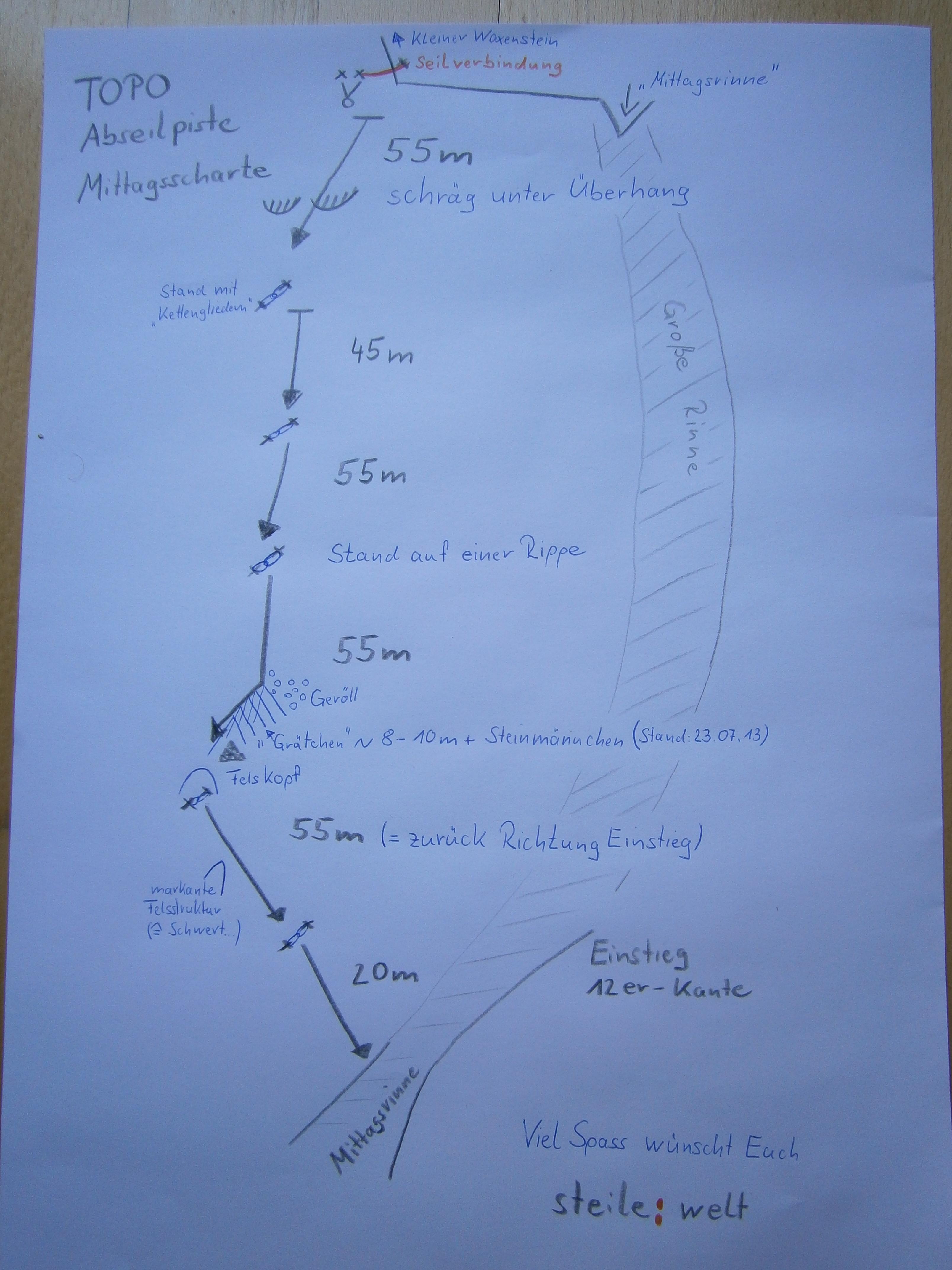
Descent: Instead of hiking down to Höllental, there is an alternative way through the Abseilpiste (Rappellin piste? don´t know the word in Englisch) from Mittagsscharte to Mittagskar (6 rappels, ~300m). The .gpx only show an approximate path of this Abseilpiste, You have to find the start of the Abseilpiste and all the next Stände (anchors/rings), as they are strategically placed in “hidden” places (to protect them from falling rocks) it is not so easy to spot them from above. So, this is really “alpine” rappelling and cannot be compared with rappelling in a Klettergarten/Kletterhalle.
Info about the Abseilpiste:
Topo Abseilpiste Mittagsscharte
Route summary:
Ascent
0. Hammersbach -> Mandl [up to T5, I-II]
1. Mandl -> Kleiner Waxenstein [T6, II]
2. Kleiner Waxenstein -> Mittagsscharte [2 Rappels: 25 m and 20 m]
3. Mittagsscharte -> Zwölferkopf [T6, II]
4. Zwölferkopf -> Großer Waxenstein [T6, III, one short rappel]
Descent
5. Großer Waxenstein -> Schafsteig [T6, II]
6. Schafsteig -> Mittagsscharte [T6, I?]
7. Mittagsscharte -> Mittagskar [6 rappels (~285 m in total): 55m, 45m, 55m, 55m, 55m, 20m]
8. Mittagskar -> Hammersbach [up toT5?]
| Technical Difficulty | Very Difficult | |||||||||||
|---|---|---|---|---|---|---|---|---|---|---|---|---|
| Gear | Helmet , Gloves , Ropes | |||||||||||
| Popularity | 1 | |||||||||||
Route statistics
| Highest point | 2276m | |||||||||||
|---|---|---|---|---|---|---|---|---|---|---|---|---|
| Total gain | 1573m | |||||||||||
| Total loss | 1571m | |||||||||||
| Duration | 06h09m | |||||||||||
| Distance | 11.2Km | |||||||||||
| Rating | 1743 | |||||||||||
Best Season
Forecast
Author