Flüelen - Brunnen ( Weg der Schweiz ) | 824m
| Elevation gain |
| Elevation loss |
| Distance |
| Duration |
| Highest altitude |
| Rating |
Route Information
The path runs in and along the vertical rock face above Lake Uri. The rock arches as well as the numerous steps and wooden walkways demonstrate the attention to detail. Tell’s Chapel, the largest glockenspiel in Switzerland, and a wonderful mountain panorama lend further charm to the hike.
Flüelen is located on the shore of Lake Uri under the steep forested hillside of the Eggberge. The former church is now used in a variety of ways and houses a rock crystal exhibition. Rudenz Castle, with its castle park that is open to the public, also invites you to linger. In the south of Flüelen lies the natural paradise of the Reuss Delta, which is alluring with its flat moors, reed meadows and bathing islands.
Between the train station and the landing stage, where steamboats dock regularly, is the start of the hike along the shore of the lake in a northerly direction. The cantons gifted the Swiss Path to the population of Switzerland in 1991. The cantons of Schaffhausen, the two Appenzells and St. Gallen were allowed to design this section of the trail in the order in which they joined the Swiss Confederation.
A wooden bench shaped like a deck chair invites you to relax. Screeching seagulls, honking ships and the warm Foehn wind ensure a holiday mood. The train sounds remind you of the presence of the important north-south axis from Zurich to Milan, which runs parallel to long stretches of the route.
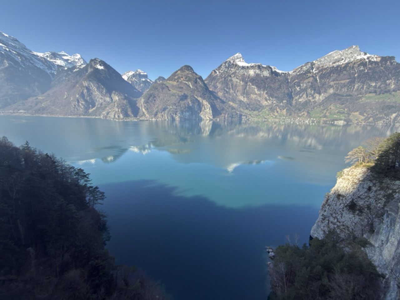
On the lake promenade, you can walk comfortably along the hillside between the tracks and water. A narrow wooden footbridge goes underneath the Sulzegg viaduct. You are fast approaching the spectacular section on the rock faces of the Axenflue. The path was built into and through the rock and it provides a vertical view downwards from the old Axenstrasse onto the rock face to the azure blue Lake Uri and the surrounding mountains.
The narrow paths are well maintained, and incorporate disused railway sleepers that serve as steps. Huge rock arches and pillars support the mountain under which the hikers pass, and they give you an idea of the effort involved in building the old Axenstrasse. Before this was opened in 1865, the important north-south traffic between Brunnen and Flüelen had to be loaded onto ships.
Now comes the descent back to the lake shore. Eighty steps above the Tell’s Chapel, the Swiss chocolate industry has created the largest glockenspiel in Switzerland. During the day, one of around twenty melodies is played for the first few minutes of every hour. Further down on the lake shore, Wilhelm Tell is said to have escaped by jumping out of the bailiff Gessler's boat to the Tellsplatte to save himself. Four frescoes in the chapel depict the Rütli oath, the shooting of the apple, Tell’s leap and Gessler’s death in the Hohle Gasse.
A stunning trail follows the shore past the Tellsplatte. Beneath gnarled pine trees and past steep cliffs, you pass by several attractive places rest. Sometimes the trail is right next to the water, with small waves engulfing the large boulders beneath them. You reach Sisikon via winding steps and with a wonderful view of the surrounding mountains. The valley station of the Twärrüti-Buggialp cable car is above Sisikon. It offers a panoramic journey with a view over Lake Lucerne to the Rigi and the Pilatus.
Overlooking the luminous blue Lake Lucerne and the wooded hills that surround it, the path goes up and down well-paved trails through attractive forests. The Chapel Trail near Morschach is a reminder of the rich history of the region.
Sisikon is located in the flat river delta of the Riemenstalden stream, surrounded by impressive cliffs and steep forested hillsides. This is where the fourth and last stage of the Swiss Path starts. The cantons gifted this cultural trail to the population of Switzerland in 1991. Ticino, the French-speaking region and Valais were allowed to design the fourth section of the trail because they were the last to join the Swiss Confederation.
This stage begins at Sisikon station, which is on the Gotthard Railway line. The Fronalpstock rises steeply in the east. On the other side of the lake, the Uri Rotstock glacier pyramid is impressive, reaching a height of almost 3,000 metres. The trail first follows the stream for a short distance before crossing it. Then the climb begins on the steep hillside with narrow bends through the shady deciduous forest.
Numerous benches, railings and paths cut into the rock ensure a comfortable and reassuring hike. There is an impressive view downwards through small clearings, with the lake becoming more and more remote as you ascend. You reach the hamlet of Tannen at an altitude of 803 metres through the Täfeliwald forest. You will see the oldest wooden house in the canton of Schwyz here; built in 1341. From the vantage point on the hilltop with its lime tree, which is somewhat atypical for this region, you can see across the lake to the Rütli, Seelisberg and other highlights on this first stage of the Swiss Path.
You soon reach the highest point, then continue progressively downhill on a surfaced panorama trail to the intermediate destination of Morschach. You pick up the Chapel Trail at the Franz-Xaver chapel. This circular route south of Morschach leads past five sacred buildings. The area is also famous for the family holiday paradise Swiss Holiday Park, and is located on a high plateau by Lake Lucerne. As early as 1869, Queen Victoria of England, and sometime later Winston Churchill, travelled to Morschach on holiday.
The Axenstein viewing platform is located just before the descent through the Ingenbohl Forest. The panoramic view is magnificent. The mountains and hills that rise around the lake can be spotted from the Alpenzeiger viewpoint. Far below, you may see surfers and sailing boats on the bright blue lake, and historic steamboats heading for the docks.
There is now a comfortable hike through a superb forest, back to the lake in the town of Brunnen. Life is vibrant in this important tourist resort during the summer months. King Ludwig II of Bavaria travelled here. He was regularly rowed out onto the lake at midnight to listen to the alphorn being played for him in front of the fairy-tale mountain backdrop.
The Swiss Path ends here. However, if you have not yet had enough, you can do a circuit of the whole lake on the Waldstätter Trail.
| Technical Difficulty | Easy | |||||||||||
|---|---|---|---|---|---|---|---|---|---|---|---|---|
| Gear | ||||||||||||
| Popularity | 1 | |||||||||||
Route statistics
| Highest point | 824m | |||||||||||
|---|---|---|---|---|---|---|---|---|---|---|---|---|
| Total gain | 848m | |||||||||||
| Total loss | 842m | |||||||||||
| Duration | 04h55m | |||||||||||
| Distance | 15.6Km | |||||||||||
| Rating | 1023 | |||||||||||
Best Season
Forecast
Author